Ads by Google
Map of Bahia, Brazil
« Back to Tourism in Brazil
« Back to Bahia
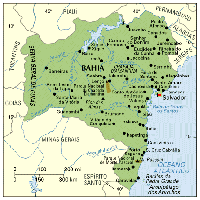 Bahia is one of the largest States of Brazil; with 567,295 km2, it´s slightly smaller than France. The population of over 13 million concentrates mostly along the coast; Salvador, the capital, is the most important city; Feira de Santana, Ilhéus, Itabuna and Juazeiro are also economically relevant.
The south of Bahia is where the History of Brazil started. A hill called Mount Pascoal (see map) was the first part of Brazil to be sighted, when Portuguese navigator Pedro Alvares Cabral arrived in 1500; Porto Seguro (Safe Haven) was the first place were the Portuguese set foot. The area of Porto Seguro - Ilhéus is one of the busiest tourist destinations of Brazil, both because of the History and because of the beaches.
More recently, the northern part of the Bahia coast has seen investments on the tourist trade; Costa do Sauípe

 , the largest conglomerate of hotels and resorts in Brazil, is about 70 km north of Salvador.
The state of Bahia is crossed from north to south by a mountain chain which is marked, in the map, as Chapada Diamantina; this same chain receives other names, like Serra do Espinhaço, in Minas Gerais, and Borborema, in Pernambuco and Paraíba.
In some parts, the chain has the shape of "Chapadões", flat top plateaus with abrupt edges; the most visited of such chapadões are in the National Park of Chapada Diamantina, in the middle of the State.
The chain divides Bahia in two clearly distinct geographical zones. To the east, where once existed the exhuberant Atlantic Forest, the soil is fertile and, despite high temperatures, rainy seasons are regular. To the west of the chain, soil is poorer and climate is drier; the predominant vegetation is cerrado; these tough conditions caused the interior to be much less developed than the coast.
The state is also crossed by the river São Francisco, the most important of Brazilian northeast; São Francisco is a permanent river, which continuously supplies water to this arid region when many other smaller rivers dry out; the São Francisco starts in Minas Gerais and goes on until the Atlantic, making borders between Bahia and Alagoas. There are short stretches of the river which are navigable, but mainly for cargoes. The large blue spot at the north is a huge dam built to hold water for the hidroelectric plant of Itaparica.
Back to Top