Brazil Travel
|
|
Ads by Google Rio Grande do Norte
Official website:
http://www.rn.gov.br
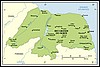
Capital: Natal Area: 53,306 km2 Important cities: Mossoró, Parnamirim, Ceará-Mirim Climate in Natal, Rio Grande do Norte The French invaded the region early in the 16th century; in 1597, to guarantee the possession, the Portuguese sent a mission to start to buil a fortress on the banks of river Potengi. That fortress was finished on Dec. 25th 1598, and, in reference to the date, the village around it was called Natal (Natal is the Portuguese word for Christmas). Later on, the Dutch invaded the fortress and stayed from 1633 to 1654, when the Portuguese reclaimed it, helped by local indians. Differently from other northeastern regions, Rio Grande do Norte didn't have a soil proper for sugar cane plantation; the capitany/province/state participated in several rebelions. The sea waters off the coast are very salty, and the salt industry grew in the 20th century. In the 1970s, petroleum was found and boosted the economy (until today, the state is the biggest producer of petroleum on land in Brazil). More recently, Natal is turning to tourism. Natal is sunny, has several beaches and is much less violent than the southern Brazilian cities.  Latest News
Recent information about the state of Rio Grande do Norte
Physical Geography
History
Travel to Rio Grande do Norte
Information about the State and its main attractions: Natal, Pipa, Jenipabu.
Economy and Infrastructure
More info and photos of Rio Grande do Norte
Links to other sites about Rio Grande do Norte Latest News
Recent information about the state of Rio Grande do Norte
Physical Geography
History
Travel to Rio Grande do Norte
Information about the State and its main attractions: Natal, Pipa, Jenipabu.
Economy and Infrastructure
More info and photos of Rio Grande do Norte
Links to other sites about Rio Grande do Norte
Back to Top |