Ads by Google
Map of Rio Grande do Norte, Brazil
« Back to States of Brazil
« Back to Rio Grande do Norte
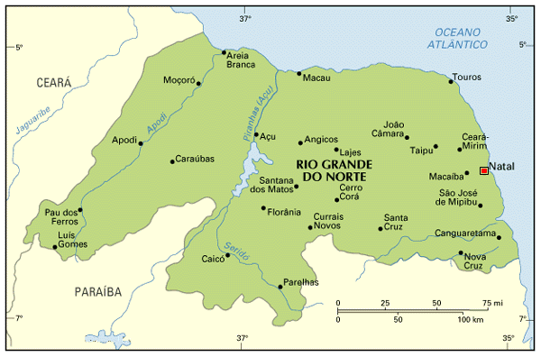 The capital of Rio Grande do Norte is the city of Natal, in the eastern coast.
Other important cities are Moçoró (about halfway between Natal and Fortaleza) and Parnamirim (not shown in the map, Parnamirim is in the metropolitan area of Natal).
Except for a narrow (few kilometers wide) ribbon along the eastern coast, most of Rio Grande do Norte is in the semi-arid zone, with high temperatures and little to moderate rain. Natal was built in a transition zone: the south of Natal was once covered by the Atlantic Forest, while to the north the semi-arid is more visible (the dunes of Natal being the most visible trace). All the interior cities are under industrialized, with a economy based on agriculture and cattle; important regional centers are Caicó, Currais Novos and Açu.
The coast can be divided in two parts: the northern coast, nearly parallel to the Equatorial Line, and the eastern coast, nearly orthogonal to it; there are significant differences between them.
Cities in the eastern coast see more rain and wind than the northern one; this caused that most touristic cities developed along the eastern line. Besides Natal, other famous beaches are: Touros and Maracajaú (north of Natal), Búzios and Pipa (south of Natal, not shown in the map); actually, almost the entire coast in punctuated with smaller touristic cities.
The northern coast has much less touristic attractions. Moçoró is a large producer of petroleum; Macau has a petrochemical mill, and a port to export the production; the area which goes westwards from Areia Branca into Ceará is the largest producer of salt in Brazil, because of the hight salinity of the sea.
The most important roads are BR-101, which comes along the coast from the south, and BR-304, which goes from Natal to Moçoró and on to Fortaleza.
Back to Top