Brazil Travel
|
|
Ads by Google Ceará
Official website:
http://www.ceara.gov.br
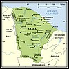
Capital: Fortaleza Area: 146,348 km2 Important cities: Juazeiro do Norte, Crato, Sobral Economy: agriculture, cattle, tourism Climate in Fortaleza, Ceara The Dutch built a fortress, which they called Schoonenborch, by the river Pajeú; in 1654, the Portuguese took over the fortress, whose name was changed to Fortaleza de Nossa Senhora de Asunção (Fortaleza is the Portuguese word for fortress). The state was part of the capitany of Pernambuco, from which it was dismembered in 1799; the province/state participated actively in the Independence, abolitionist and Republican movements. Fortaleza is today one of the most modern cities in Brazil; the city and the state have been benefiting from years of continuity in administration (the same party has won successive elections for over one decade now). Fortaleza assumed its touristic potencial, and today much of the business evolves around tourism; the city gets crowded during high season.  Physical Geography
Ceará is in the Zone of Drought
History
Drought caused many cearenses to migrate
Ceará Travel information
Culture and tourism atttractions of Ceará, Fortaleza and other cities.
Economy
Cattle and recent modernization
More info about Ceará
Other sites about Ceará and Fortaleza
Latest News about Ceará
Recent information about Ceará and Fortaleza Physical Geography
Ceará is in the Zone of Drought
History
Drought caused many cearenses to migrate
Ceará Travel information
Culture and tourism atttractions of Ceará, Fortaleza and other cities.
Economy
Cattle and recent modernization
More info about Ceará
Other sites about Ceará and Fortaleza
Latest News about Ceará
Recent information about Ceará and Fortaleza
Read also: Tourism in Fortaleza - how foreigner travellers evaluate the city Back to Top |