Ads by Google
Map of Rio de Janeiro, Brazil
« Back to States of Brazil
« Back to Rio de Janeiro
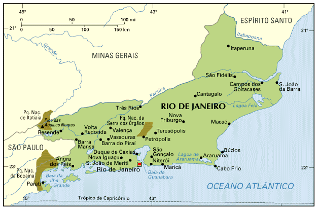 With only 43,909 km2, Rio de Janeiro is one of the smallest Brazilian States (the State of Rio, however, is a bit larger than Switzerland, and twice as large as Massachussets); from the border with São Paulo to the border with Espírito Santo, the state is about 300 km long.
The capital city, Rio de Janeiro, is on the entrance of Guanabara Bay; Niteroi, the second largest city of the State, is on the other side of the Bay, and is connected to Rio by ferries and the Rio-Niteroi bridge (14 km long). Many cities around the bay, like São João do Meriti, Nova Iguaçu, Duque de Caxias, are under influence of the capital; people live in these cities, but commute daily to Rio.
All the most important cities of Rio are at a driving distance from the capital.
The area around Búzios and Cabo Frio is called Região dos Lagos (Zone of Lakes). The area around Nova Friburgo, Petrópolis and Teresópolis is the Região Serrana (Mountains Zone); cities here are at a higher altitude, have a colder climate. In the south, Angra dos Reis has the largest concentration of private boats and yatchs in Brazil, while Parati is an important Historic city. During weekends and especially long holidalys, cariocas drive in droves to these cities; expect heavy traffic.
In the northern part of the State, Macaé is becoming the most important city, thanks to the operations of Petrobrás; notice that the largest oil reservoirs are in the Basin of Campos, but Campos (marked in the map as Campos dos Goitacazes, its full name) is NOT the center of operations.
Other important industrial area is the zone near the border with São Paulo. Volta Redonda, Barra Mansa, Resende and other cities have benefited from a big steel mill built in Volta Redonda, and have received large investments from heavy industries (particularly automobiles).
Back to Top