Brazil Travel
|
|
Ads by Google Paraíba
Official website:
http://www.pb.gov.br
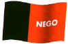
Capital: João Pessoa Area: 56,584 km2 Important cities: Campina Grande, Santa Rita, Patos, Souza Paraíba is the most oriental state of Brazil; Cabo Branco (Cape White), in the city of João Pessoa, is the easternmost point of Brazil and Americas. However, the affirmation that "the dawn comes first in Paraíba" is false; because of the inclination of Earth, the sun may be seen first in southern latitudes (I remember that, on January 1st. 2000, groups of people gathered in João Pessoa to watch the first sunrays of the century - yes, many people thought that that day was the beginning of the 21st century -, but reports on TV announced that, for example, Rio de Janeiro would see the sun before Paraíba). The flag brings the word NEGO, which in Portuguese means "(I) deny". In the Presidential election of 1930, the official candidate was Júlio Prestes, from São Paulo, who had the support of Epitácio Pessoa, uncle of João Pessoa, then governor of Paraíba; when asked to support Júlio Prestes, João Pessoa responded with a telegram: Nego (I deny). Shortly after the election, won by Júlio Prestes, João Pessoa was killed; the red of the flag represents the blood of Pessoa, while the black represents the mourning of the paraibanos. Click the link below to read more about the History of Paraíba.  Latest News
Recent information about the state of Paraiba.
Physical Geography
Paraíba is affected by the drought
History
History of Paraíba
Economy and Infrastructure
Dependancy on agriculture
More info and photos of Paraíba
Links to other sites about Paraiba Latest News
Recent information about the state of Paraiba.
Physical Geography
Paraíba is affected by the drought
History
History of Paraíba
Economy and Infrastructure
Dependancy on agriculture
More info and photos of Paraíba
Links to other sites about Paraiba
Back to Top |