Brazil Travel
|
|
Ads by Google AMAPÁ - BRAZIL
Official website:
http://www.ap.gov.br
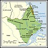
Capital: Macapá Area: 143,453 km2 Important cities: Santana Economy: manganes, lumber, castanha-do-pará The northernmost point of Brazil is the Oiapoque, in the north of Amapá. It´s one of the least populated States in Brazil; the long distances made economic development difficult. On the other hand, the part of the Amazon forest which covers the State is one of the most preserved. Because of the privileged position (it´s one of the points in South America closest to Europe), this area was disputed by Portuguese, British, Dutch and French; several diplomatic missions were necessary to settle the definitive borders between Brazil and Guyana. In the first half of 20th century, very large reservoirs of manganese were found in Amapa; the exploration of this mineral is still the main economic activity of the State.  Latest News
Recent information about Amapa
Physycal Geography
History
Travel to Amapá
Information about culture and tourist attractions of Amapá.
Economy and Infrastructure
More info and photos of Amapa
Links to other sites about Amapa Latest News
Recent information about Amapa
Physycal Geography
History
Travel to Amapá
Information about culture and tourist attractions of Amapá.
Economy and Infrastructure
More info and photos of Amapa
Links to other sites about Amapa
Back to Top |