Ads by Google
Map of Minas Gerais, Brazil
« Back to Brazil Travel page
« Back to Minas Gerais
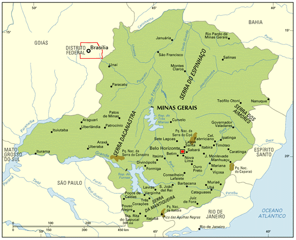 With an area of 588,383 km2 (a little bigger than France), Minas Gerais is the third largest Brazilian State (after Amazonas and Pará); with nearly 18 million people, it´s the second most populated State (after São Paulo).
The capital is Belo Horizonte (which translates as "Beautiful Horizon"); the metropolitan area of Belo Horizonte concentrates much of the industries of the State.
The name Minas Gerais ("General Mines", or "Large Mines") is a reference to the fact that, during the 18th and 19th centuries, large mines of gold and precious stones were found in the State; some cities prospered much because of the gold, and still have a rich architecture: Ouro Preto, Mariana, Barbacena, São João del Rei.
The State is covered with moutain chains; the gold production declined, but several other minerals were found; the Vale do Rio Doce, one of the largest mining companies in the world, owes its name to the Rio Doce (Sweet River), which flows from Minas Gerais to Espírito Santo.
Serra do Espinhaço is a particularly important mountain chain; changing names a few times, this chain goes all the way up until Rio Grande do Norte, and plays and important role in defining the climate of several States, as it separates the wet coast from the arid sertão.
There are big differences between the south and north of Minas Gerais. The south has tropical climate (rainy and wet seasons well defined), and the proximity of the large consuming markets of São Paulo and Rio helped develop the economy of several cities. The north suffers the impact of the semi-arid climate (little rain, impairing the soil); cities are much less populated and much less developed; the Vale do Jequitinhonha (region around the river Jequitinhonha) is one of the poorest areas of Brazil.
Back to Top