Advertising by Google
Mato Grosso - information travel
Area: 3985 km²
Population: 508 156 inhab. (est. 2003)
See map of Mato Grosso.
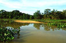
Cuiabá, near the geographical center of Brazil, is also in the middle of three of the largest Brazilian ecosystems. To the north, towards the borders with Amazonas and Pará, one can reach the Amazon jungle. A good part of the eastern and souther parts of the State of Mato Grosso are covered by the cerrados. And in the southern part, covering the south of Mato Grosso and the northern area of Mato Grosso do Sul, tourists can visit the Pantanal.
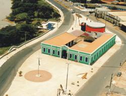
Cuiabá, the capital of the Mato Grosso State was founded on the discovery of gold on the region by bandeirantes, on the beginning of the XVIII century. From that time, the city keeps the narrow streets that can be seen on the oldest part of the city center.
 The city is a mandatory stop to those going to visit the natural beauties of the Mato Grosso State, like the Parque Nacional da Chapada dos Guimarães (Chapada dos Guimarães National Park) and the North of Pantanal. A good option is to visit Águas Quentes, which has an aquatic park containing natural thermal water and a vast forest reserve. The city has good restaurants of typical food of Pantanal.
Cuiabá is a city that is relatively peaceful, flat and planted with trees where traces of the colonial past mingle with present day development. But it is much more than that. Intersected by the River Cuiabá, the city was the destination of explorers and adventurers who in the 18th and 19th centuries set out from São Paulo on river expeditions, sailing up the River Tietê and the network of tributaries of the Rivers Paraná and Paraguay to the River Cuiabá, settling in the centre of Brazil, setting up trading posts and going in search of the region's abundant gold reserves.
 Dating from those times, the city has churches such as the Church of Rosário, built by slaves in 1722 and where the high altar is painted in gold; there is also the Ramis Bucair Museum of Stones, housed in an former mansion where in addition to a display of stones, there are around 4,000 archaeological exhibits, including the femur of a 120 million year old tyrannosaurus and stone axes dating from the neolithic period, found in the region. Also from the past, the city preserves traditions such as the Festival of São Benedito.
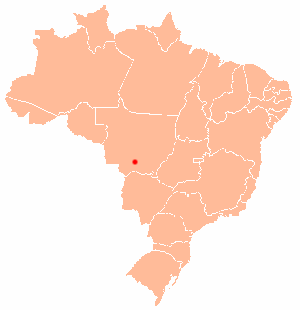
Cuiabá in the Brazil map
From the city of Cuiabá, and almost as an extension to it, it is possible to make out the Chapada do Guimarães a place that is steeped in mystery, with crags and canyons that appear to transform the sandstone mountains into a city of stone. On certain days of the year when the Chapada is covered in snow, walking around there is like being on a film set, wandering amongst typical trees of the Cerrado, (scrublands) with their twisted, leafless trunks, decorated with the whitish air of a Sherlock Holmes novel. This scenario, which is also where the rivers rise before flowing into the Amazon Basin to the north and the River Plate Basin to the south, has helped create the mystique that in the Chapada it is possible to regenerate energy and that even the UFOs (Unidentified Flying Objects)s were attracted by it - there is even an "Ufoport" at its highest point, the Morro de São Gerônimo.
A remarkable city on account of its cuisine based on fish from the rivers of the region, Cuiabá is also one of the ports for the Pantanal, (wetlands) by means of the roads that lead to Porto Jofre or to Poconé and Águas Quentes, a town where the waterfalls, mountain climate and thermal springs at temperatures between 32 and 42 ºC, delight the visitors.
Read more:
Cuiaba official site. Maintained by the city government.
Universidade Federal do Mato Grosso. The Federal University of Mato Grosso, campus of Cuiabá.
Back to Top