Ads by Google
Map of Goiás, Brazil
« Back to States of Brazil
« Back to Goiás
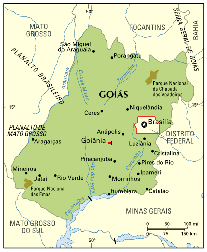 Most central State of Brazil, Goiás has neither border with the Ocean nor with other countries. With 341,289 km2 (a little smaller than Germany), it´s still the 6th largest Brazilian State (it used to be bigger, before the State of Tocantins was dismembered from Goiás).
The large extensions of cerrados (plain fields with arbustive vegetation) favoured the development of agriculture and cattle raising in Goiás; the state is one of the largest producer (and exporter) of soybean, and has the second largest bovine herd in Brazil.
The capital city, Goiânia, was inaugurated on October 24th 1933; the former capital was the city of Goiás (not shown in the map), which is located about 150 km west of Goiânia (this map shows the relative position between Goiás, Goiânia and Brasília). Being a planned city, Goiânia offers all the commodities of modern society, without the problems brought by overgrowth.
Because of its central position, the State of Goiás was chosen to host the new Federal capital, Brasília. In the 1950s, when a new place was being surveyed to build Brasília, many people suggested that Goiânia would be the best place; however, political reasons prevailed, and billions of dollars were spent to build a new city from the scratch.
Other important cities are Rio Verde, Luziânia (concentrate many farms) and Anápolis (because of its central position, the best Brazilian Air Force basis is located here). Goiás has a few National Parks (the map shows Chapada dos Veadeiros and Parque das Emas, the two best known) and some indian reserves.
Back to Top